Monitoring or Broadcasting of Sporting and Audiovisual Events with Drones
11/23/2023Photogrammetry and topography using drones

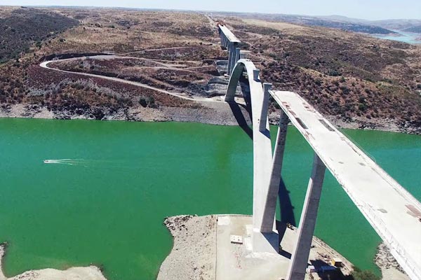
Fotogrametria realizada con drones sobre el castillo de Medellín en Badajoz (SPAIN).
Photogrammetry and topography using drones
Drone photogrammetry and surveying is an advanced data acquisition technique that uses drones equipped with high-resolution cameras and sensors to capture images and geospatial data from the air. By processing these images, digital terrain models, 2D and 3D maps, orthomosaics and precise terrain measurements are generated.
This technology has revolutionized the surveying industry and allows for faster, safer and more economical surveys, providing valuable information for various applications in construction, agriculture, urban planning, environmental monitoring, ….. Drones offer a unique perspective that provides a complete and detailed view of the terrain, improving decision making and efficiency in multiple sectors.
How do drones benefit surveyors?
Drones are increasingly being used in surveying as they offer a number of advantages over traditional methods. Drones can capture high-resolution and accurate aerial data, enabling the creation of 3D models and precise maps of areas. In addition, drones can access areas that would be difficult or impossible to reach on foot, making them ideal for construction site inspection, natural disaster monitoring and climate change monitoring.
Drones are also more efficient than traditional methods, as they can capture large amounts of data in a short time. This can save companies time and money, and can help improve worker safety by reducing the need to enter hazardous areas.
As a result of these advantages, drones are fast becoming an essential tool for surveying. They are used in a wide range of industries, including construction, mining, agriculture, urban planning and defense.
What is a drone survey?
It is an increasingly popular technique that involves rendering a surface or terrain relief using a drone equipped with appropriate sensors. These drones capture data from different perspectives, allowing the creation of highly accurate orthomosaics and 3D models. The photogrammetry process transforms these images into valuable assets for decision making and data analysis.
Drones are particularly useful for land surveying, roof inspections, bridge and building analysis, infrastructure maintenance and construction sites. The speed and safety of data collection, combined with the ability to access hard-to-reach areas, have made drones an essential tool in surveying.
Why use a surveying drone?
Using a surveying drone in the field of photogrammetry and surveying offers a number of significant advantages that have revolutionized the way in which analyses and surveys are carried out. Some of the main advantages are:
– Improved efficiency: Drones can collect aerial data over large areas of land in much less time compared to traditional methods. This increased efficiency allows surveyors to perform faster and more complete surveys.
– Cost reduction: The use of drones for surveying reduces the need for ground equipment and personnel, leading to significant savings in labor and resources. Drones also allow easier access to remote and hard-to-reach areas, avoiding the need for additional infrastructure.
– Enhanced safety: Drones allow surveyors to carry out inspection and mapping work from a safe location, avoiding exposure to dangerous terrain or difficult to access areas. This reduces risks to personnel and improves workplace safety.
– Accurate and detailed data: Drones equipped with advanced sensors, such as high-resolution cameras or LiDAR, can capture extremely accurate and detailed topographic data. These data allow the creation of 3D maps, elevation models and orthomosaics with a high fidelity to reality.
– Versatility in applications: Drone surveying is highly versatile and can be applied in a variety of industries, such as construction, mining, agriculture, land management, urban planning and environmental research. Drones can be adapted to different needs and project sizes.
– Monitoring and tracking: Drones facilitate periodic monitoring and tracking of projects under construction or areas under development. This ability to review and evaluate progress on a frequent basis allows to detect possible deviations from the original plan and to take corrective actions in a timely manner.
– Real-time updated information: With drones, surveyors can obtain real-time updated information on the status of a terrain or project. This allows for more agile and accurate decision making, especially in situations that require quick responses.
Drone survey data processing
Processing survey data with drones is an essential step in maximizing the efficiency of information gathering. During drone missions, images are taken from different perspectives and angles. These images are processed using photogrammetry software, which generates orthomosaics and 3D models.
Drone photogrammetry software is a vital component of a drone surveying operation, as it converts the data collected into meaningful resources that facilitate decision making. It is important to note that image processing can be a lengthy process, depending on the number of images and the performance of the hardware used.
How accurate is a drone in surveying measurements?
The accuracy of topography measurements made by drones can vary depending on several factors, including the type of drone used, on-board sensor equipment, atmospheric conditions, data processing and methodology employed. In general, modern drones equipped with state-of-the-art technology can achieve levels of accuracy that are suitable for most surveying applications.
To obtain accurate measurements in topography with drones, the following aspects must be considered:
– RTK or PPK technology: Drones equipped with RTK (Real-Time Kinematic) or PPK (Post-Processed Kinematic) systems can achieve real-time or post-flight accuracy, respectively. These systems use GPS or GNSS signals to correct errors and provide more accurate measurements.
– Calibration and georeferencing: It is important to properly calibrate the drone and sensors prior to flight. Well-distributed ground control points should also be used for georeferencing, which helps to improve the accuracy of the measurements.
– Image resolution and quality: The accuracy of topographic measurements depends largely on the quality of the images captured by the drone. High resolution cameras and LiDAR sensors provide more accurate data.
– Processing method: Data processing is a critical step to obtain accurate measurements. The use of photogrammetry or point cloud processing software must be done with care to ensure accurate results.
In general terms, topographic drones can achieve centimeter or even sub-centimeter accuracy in measurements, making them suitable for applications such as land surveys, digital elevation model generation, 3D mapping and volume calculations. However, it is important to note that accuracy may vary depending on the complexity of the terrain and flight conditions.
In applications where even higher accuracy is required, such as monitoring civil engineering works or detailed surveys for infrastructure projects, additional methods may be needed, such as the use of total stations or airborne LiDAR systems, which can achieve even higher accuracy, but also involve higher costs and complexity in the process.


