Technical Inspections with Thermal Camera on drones
11/09/2023
Monitoring or Broadcasting of Sporting and Audiovisual Events with Drones
11/23/2023
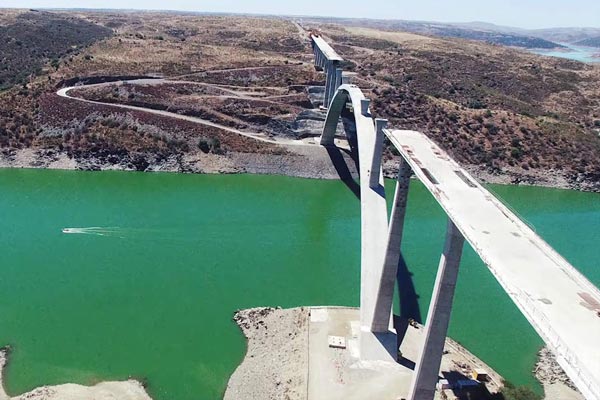
Monitoring of works with drones. Evolution of works and infrastructure with a drone. Bridge over the Tagus (Spain).
Monitoring of works and infrastructures with drones
Drone monitoring of construction sites and infrastructure is a growing trend that has revolutionized construction site management by providing accurate and essential data without disrupting operations, saving construction companies time and money. Previously, managing a large construction project involved using communication systems to distribute knowledge and progress meetings to forecast the schedule and budget for each period. However, this manual process, involving sketches and calculations in notebooks, was slow and error-prone.
Why is the construction industry adopting drones?
The use of drones in construction management has proven to be a faster, easier and safer way to acquire essential and accurate data to manage and monitor progress on site in real time. More and more leading companies in disruptive technology have joined this trend and are using drones in their construction projects in the main developed countries of the world.
One of the main reasons the construction industry is adopting drones is the significant improvement in measurement accuracy. Compared to traditional methods that often result in discrepancies in quantities produced, drones allow weekly overflights that save time and provide accurate site measurements. This avoids the need for costly and tedious additional measurements at the end of the month, which in turn improves payment planning and cash flow. It is also an effective way to audit and justify progress.
Drone mapping to monitor construction site progress
Drone mapping has also proven to be highly beneficial for monitoring construction progress. The creation of a single source of information, through the collection of accurate data by drones, allows for precise jobsite tracking of progress, helping to forecast future material needs, update budgets and monitor overall project progress. Field engineers can verify that everything is built and billed correctly by reviewing plans and specifications and working closely with subcontractors.
With the use of drones, additional benefits have been found that were not initially anticipated. The images taken by the drones have been used for centimeter locations, such as water shutoff valves and newly installed sewer pipes. When problems arise, drone imagery becomes an invaluable tool for quick troubleshooting.
Drones have enabled a significant improvement in the safety of construction sites and infrastructure during flight operations. The use of visual observers and training of personnel in drone operation ensures compliance with regulations and avoids unnecessary risks for the construction company’s workers.
2D aerial maps for construction
In terms of data processing, the availability of accurate 2D aerial maps and 3D models has been key to improving construction site progress management. Drones have made it possible to measure distances, analyze shapes and count objects with great precision. The images captured by the drones are processed on online platforms, or post-processed, which avoids the need to carry powerful laptops into the field and facilitates access to the data from any location with an Internet connection.
Construction companies have recognized the tangible benefits that drones and photogrammetry offer, taking advantage of these technologies to optimize their operations, save costs and improve efficiency in their projects. The combination of drones and other technologies, such as BIM modeling, is leading to the digitization of the construction site and maximizing the efficiency of technological resources, creating a digital twin.
The benefits of using drones in construction
The use of drones in the monitoring of construction sites and infrastructure in the construction industry offers a wide range of benefits that have revolutionized the way projects are managed and executed. Some of the main benefits include:
– Precision and accuracy: Drones equipped with advanced sensors, such as high-resolution cameras and LiDAR, can capture accurate and detailed construction site data. This includes aerial imagery, 3D models and topographic data that allow for more informed decision making and accurate planning.
– Monitor and track construction sites and infrastructure in real time: Drones can perform regular flights over the construction site to provide real-time updates on the progress of the project. This allows management teams and stakeholders to monitor progress, identify potential problems and take corrective action in a timely manner.
– Improved safety: The use of drones reduces the need for workers to access dangerous or difficult-to-access areas on the construction site. By minimizing workers’ exposure to potential hazards, workplace safety is improved, in addition to savings in personnel costs.
– Efficiency and time savings– Drones can collect data in a short period of time and faster than traditional methods. This streamlines the data collection process and allows teams to focus on higher value-added tasks.
– Cost reduction: By improving efficiency, reducing errors and minimizing the need for manual measurements, the use of drones reduces operating costs and optimizes resource allocation.
– Increased range and coverage– Drones can access areas that are difficult to reach or dangerous for humans, allowing for more complete and comprehensive construction site monitoring of the entire construction site.
– Enhanced visualization and communication: Drone-generated 3D images and models provide a clear and detailed visual representation of the construction site. This facilitates communication between team members, stakeholders and customers, which improves understanding and collaboration on the project.
– Data-driven planning and decision making: Data collected by drones provides a solid foundation for informed planning and decision making. This allows for more strategic project management and reduces the risks associated with uncertainty.
– Documentation and recording: Drones can capture images and videos over time, providing valuable documentation and historical record of the project’s progress. These records are useful for auditing, reporting and compliance monitoring purposes.
– Marketing material: High quality aerial images and videos captured by drones can be used to promote the construction project and show the development of the project.
Conclusions
In summary, the use of drones in construction site and infrastructure monitoring offers significant benefits that improve project efficiency, safety and quality. This technology has proven to be a valuable tool for the industry, enabling smarter and more effective management of construction projects.
Lorem ipsum dolor sit amet, consectetur adipiscing elit. Ut elit tellus, luctus nec ullamcorper mattis, pulvinar dapibus leo.


