3D Photogrammetry and Mapping with Drones
Drone photogrammetry generates orthophotos, point clouds and 3D models from hundreds of overlapping images. With RTK positioning, we achieve survey-grade accuracy and rapidly cover complex areas, reducing field costs and supporting analysis, design and planning in civil engineering, urban development and CAD/GIS workflows.
We control GSD and overlap to produce outputs comparable over time: scaled orthomosaics, contours/DTM, mapping ready for CAD/GIS and traceable volume calculations. We deliver production-ready files with technical support, accelerating decisions, avoiding reprocessing and improving field safety with complete, verifiable documentation.
What Does 3D Photogrammetry and Mapping with Drones Involve?
Drone photogrammetry captures hundreds of overlapping images that are processed to generate high-fidelity orthophotos, dense point clouds and 3D models. With RTK, we achieve survey-level precision in complex areas, reducing field time and cost compared to traditional methods while improving safety and coverage in demanding environments.
We control GSD and overlap, and when required, integrate GCPs, ensuring outputs are comparable between dates. We derive contours/DTM, calculate volumes, and deliver mapping ready for CAD/GIS integration. This standardised workflow supports design, urban planning and construction monitoring using measurable, repeatable and fully auditable criteria.
We deliver files in GeoTIFF, LAS/LAZ, DXF and OBJ formats, together with quality reports and metadata. Traceability and historical records by campaign enable audits, temporal comparisons and change detection. The result: faster decisions, fewer reprocesses and solid technical documentation for production, certification and project management.
Benefits of 3D Photogrammetry and Mapping with Drones
Drone photogrammetry accelerates mapping processes: precise orthophotos, 3D models and dense point clouds for measurement and planning. Greater coverage in less time and fully georeferenced data to support agile decision-making in construction and GIS environments.
Speed compared to traditional surveying.
RTK accuracy and comparable outputs.
Coverage of large and complex areas.
Reliable measurements (areas, distances, elevations).
Seamless CAD/GIS integration.
Optimised cost versus classical topography.
We deliver reports and files ready for CAD/GIS (GeoTIFF, LAS/LAZ, DXF, OBJ), with RTK traceability and consistent criteria between campaigns, reducing setting-out time and overall field costs.
Complementary Services

Deliverables and Outputs
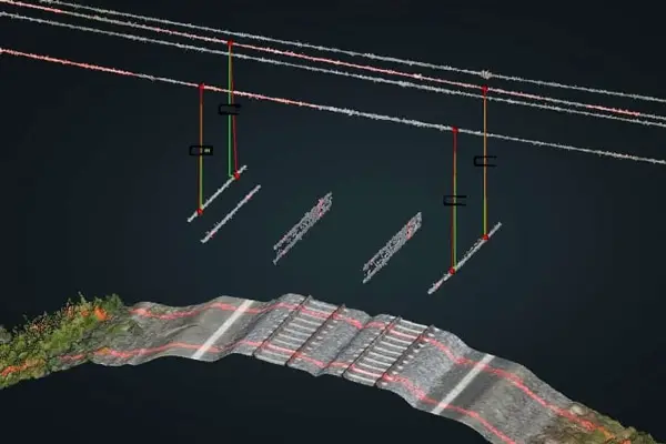
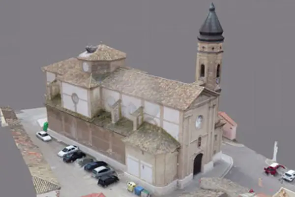
From each flight you obtain a scaled orthophoto, dense point cloud, 3D model, contours/DTM, mapping ready for CAD/GIS and traceable volume calculations — all fully georeferenced and comparable by date.


Why Choose SG solutions drones
We combine technical experience with advanced Zoom + RTK + thermal technology. We deliver auditable reports in under 48 hours and a repeatable history per project area, optimising costs and improving data reliability.

Frequently Asked Questions about 3D Photogrammetry and Mapping
We operate with RTK positioning and controlled GSD/overlap. For higher precision requirements, we integrate GCPs depending on the project’s needs.
Orthophoto, dense point cloud, 3D model, contours/DTM and mapping ready for CAD/GIS integration.
Yes. Deliverables enable surface, distance and volume measurements, fully traceable by date for temporal comparison.
We deliver in GeoTIFF, LAS/LAZ, DXF, OBJ and standard GIS packages for direct integration into your workflow.
For construction or rapidly changing environments, we plan periodic monitoring flights (weekly, bi-weekly or monthly) to enable reliable temporal comparison.
Related Services You May Also Be Interested In
Expand digital modelling with technical site control and high-precision structural captures for engineering projects.